Interactive Map
INTERACTIVE PROPERTY MAP OF CROMWELL STATION
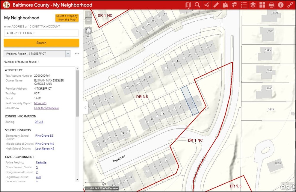
Want to know anything and everything about your own property and every other property in Cromwell Station? Where are your property lines? What are the dimensions of your property? What is the current tax assessment? When was it purchased and for how much? What are the neighborhood school districts? The police precinct? And much much more.
This interactive map was prepared by Baltimore County and reveals an amazing amount of detail about where we live.
- Click on the link below, and then click on VISIT MY NEIGHBORHOOD.
- Click on “I agree to the above terms and conditions”, and then click on “OK”.
- Enter a street address or tax number and that will take you to a page like the one below, highlighting the property lines of the address you entered.
- There is a handy measuring tool / icon in the upper right hand corner. It looks like a ruler. This can help you determine exact property boundaries between homes or between a home and the common land held by the home owners association. Choose "distance" to measure the precise width and depth of your property. Be patient. It takes a little practice. It's basically a process of "click and drag."
Pages
- Home
- CC&Rs
- Calendar
- Meeting Minutes
- Discussion Forum
- Home Maintenance
- Colors & Painting
- Exterior Modifications
- Modification Requirements
- Decks
- Doors, Lights, & Hardware
- Lawns and Gardens
- Miscellaneous
- Rear of House
- Roof
- Replacement Windows
- Resident Directory
- Board of Directors
- Architectural Review Committee
- Pet Directory
- Interactive Map
- Use Of Common Spaces
- Selling Or Renting
- HOA Dues
- Trash & Recycling Information
- Tree Information (FAQ)
- Landscaping and Turf Management
- Landscaping map
- Vehicles And Parking
- EV Charging Stations
- Useful Links
- Contact
- 2025 Holiday Decorating Contest